Geolocate

Hemsby topographic map

Click on the map to display elevation.

About this map

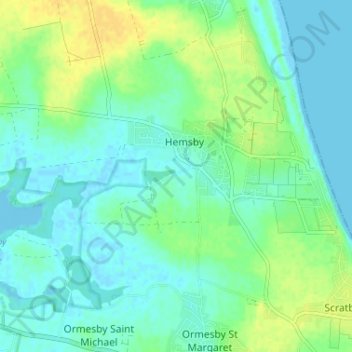
Name: Hemsby topographic map, elevation, terrain.

Location: Hemsby, Great Yarmouth, Norfolk, England, United Kingdom (52.68399 1.65025 52.70393 1.71506)

Average elevation: 26 ft

Minimum elevation: -13 ft

Maximum elevation: 75 ft

Gear up for your next adventure:

🌐World Map Poster - Decorative world maps with topographic info
🕶️Glacier Sunglasses - Side shields to protect eyes from high-altitude snow glare
🧣Merino Neck Gaiters - Multi-functional headwear for wind and sun protection
🌎3D Topographic Globes - Raised relief globes for a tactile understanding of geography
📚USA Hiking Guide Books - Top trail guides and map books

As an Amazon Associate, this site earns from qualifying purchases at no extra cost to you.