
Make a donation
Gear up for your next adventure:
As an Amazon Associate, this site earns from qualifying purchases at no extra cost to you.
Pico El León topographic map
Click on the map to display elevation.
Make a donation
Gear up for your next adventure:
As an Amazon Associate, this site earns from qualifying purchases at no extra cost to you.
About this map
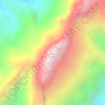
Name: Pico El León topographic map, elevation, terrain.
Average elevation: 13,514 ft
Minimum elevation: 11,434 ft
Maximum elevation: 15,338 ft
Make a donation
Gear up for your next adventure:
As an Amazon Associate, this site earns from qualifying purchases at no extra cost to you.
Other topographic maps
Click on a map to view its topography, its elevation and its terrain.
Parroquia Juan Rodríguez Suárez
Venezuela > Estado Mérida > Municipio Libertador
Average elevation: 4,800 ft
Parroquia Mariano Picon Salas
Venezuela > Estado Mérida > Municipio Libertador
Average elevation: 5,840 ft
Make a donation
Gear up for your next adventure:
As an Amazon Associate, this site earns from qualifying purchases at no extra cost to you.
Parroquia Gonzalo Picón Febres
Venezuela > Estado Mérida > Municipio Libertador
Average elevation: 10,561 ft
Make a donation
Gear up for your next adventure:
As an Amazon Associate, this site earns from qualifying purchases at no extra cost to you.
Parroquia Antonio Spinetti Dini
Venezuela > Estado Mérida > Municipio Libertador
Average elevation: 6,132 ft
Make a donation
Gear up for your next adventure:
As an Amazon Associate, this site earns from qualifying purchases at no extra cost to you.
Parroquia Caracciolo Parra Perez
Venezuela > Estado Mérida > Municipio Libertador
Average elevation: 5,023 ft
Parroquia Gonzalo Picón Febres
Venezuela > Estado Mérida > Municipio Libertador
Average elevation: 10,561 ft
Make a donation
Gear up for your next adventure:
As an Amazon Associate, this site earns from qualifying purchases at no extra cost to you.
Parroquia Mariano Picon Salas
Venezuela > Estado Mérida > Municipio Libertador
Average elevation: 5,840 ft
Parroquia Antonio Spinetti Dini
Venezuela > Estado Mérida > Municipio Libertador
Average elevation: 6,132 ft
Parroquia Osuna Rodríguez
Venezuela > Estado Mérida > Municipio Libertador
Average elevation: 5,899 ft
Make a donation
Gear up for your next adventure:
As an Amazon Associate, this site earns from qualifying purchases at no extra cost to you.
Parroquia Mariano Picon Salas
Venezuela > Estado Mérida > Municipio Libertador
Average elevation: 5,840 ft