Geolocate

Horley topographic map

Click on the map to display elevation.

Horley

Horley is at an altitude of around 54 metres above mean sea level.

Wikipedia (CC-BY-SA 3.0)

About this map

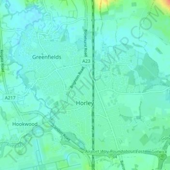
Name: Horley topographic map, elevation, terrain.

Location: Horley, Reigate and Banstead, Surrey, England, United Kingdom (51.15959 -0.19230 51.19230 -0.12775)

Average elevation: 190 ft

Minimum elevation: 164 ft

Maximum elevation: 302 ft

Other topographic maps

Click on a map to view its topography, its elevation and its terrain.

Merstham

United Kingdom > England > Surrey > Reigate and Banstead

Average elevation: 390 ft

Gear up for your next adventure:

🪶Wildlife Field Guides - Learn animal tracking and species ID
🌧️Backpack Rain Cover - Keep gear dry in wet weather
🔭Telescopic Hiking Pole - Adjustable pole for hiking stability
🩹Survival Bandages - High‑quality bandages for emergencies
📡GPS Antenna Upgrade - Enhance GPS reception in remote terrain

As an Amazon Associate, this site earns from qualifying purchases at no extra cost to you.