Geolocate

Malitlit topographic map

Click on the map to display elevation.

About this map

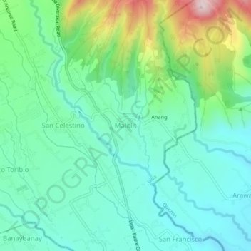
Name: Malitlit topographic map, elevation, terrain.

Location: Malitlit, Lipa, Batangas, Calabarzon, 4224, Philippines (13.89780 121.21519 13.93780 121.25519)

Average elevation: 728 ft

Minimum elevation: 371 ft

Maximum elevation: 1,732 ft

Other topographic maps

Click on a map to view its topography, its elevation and its terrain.

Lipa City Community Park

Philippines > Batangas > Lipa

Average elevation: 1,020 ft

Malepunyo Mountain Range

Philippines > Batangas > Lipa

Average elevation: 968 ft

Pangao

Philippines > Batangas > Lipa

Average elevation: 1,063 ft

Pinagkawitan

Philippines > Batangas > Lipa

Average elevation: 732 ft

Sabang

Philippines > Batangas > Lipa

Average elevation: 1,063 ft

Tambo

Philippines > Batangas > Lipa

Average elevation: 1,158 ft

6

Philippines > Batangas > Lipa

Average elevation: 1,027 ft

Lumbang

Philippines > Batangas > Lipa

Average elevation: 1,138 ft

Halang

Philippines > Batangas > Lipa > Halang

Average elevation: 561 ft

Padre Garcia-San Antonio River

Philippines > Batangas > Lipa > Bawi

Average elevation: 564 ft

Sabang

Philippines > Batangas > Lipa

Average elevation: 1,063 ft

Pangao

Philippines > Batangas > Lipa

Average elevation: 1,063 ft

Gear up for your next adventure:

🧭Pro Hiking Compasses - High-accuracy liquid-filled compasses for topographic orientation
🎒Gear Packing Cubes - Organize your backpack efficiently
🧣Hiking Neck Gaiter - Multi‑use neck protection for outdoor weather
🏫Relief Map Kits - Hands-on tools for teaching landforms and elevation
🚁Photography Drones - Capture stunning aerial views of landforms and topography

As an Amazon Associate, this site earns from qualifying purchases at no extra cost to you.