Geolocate

Detroit Lake topographic map

Click on the map to display elevation.

Detroit Lake

The water level fluctuates with snow pack, precipitation, and the water consumption of Salem, and surrounding areas. At low pool, it has a surface elevation of 1,450 feet (440 m); at the full pool season—typically May 1 to September 1—it can raise up 119 feet (36 m) to a water elevation of 1,569 feet (478 m).

Wikipedia (CC-BY-SA 3.0)

About this map

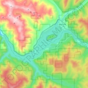
Name: Detroit Lake topographic map, elevation, terrain.

Location: Detroit Lake, Detroit, Marion County, Oregon, United States (44.67178 -122.26013 44.75093 -122.11306)

Average elevation: 2,621 ft

Minimum elevation: 1,217 ft

Maximum elevation: 4,879 ft

Gear up for your next adventure:

🧭Orienteering Set - Complete compass and map reading kit
📚Navigation Handbooks - Master the art of reading topographic maps and using a compass
🦶Hiking Gaiters - Keep debris and water out of your boots
🩳Quick‑Dry Hiking Shorts - Comfortable and quick‑dry shorts for summer hiking
🥤Water Filter Bottle - All‑in‑one filter bottle for safe hydration

As an Amazon Associate, this site earns from qualifying purchases at no extra cost to you.