Geolocate

Huidong County topographic map

Click on the map to display elevation.

About this map

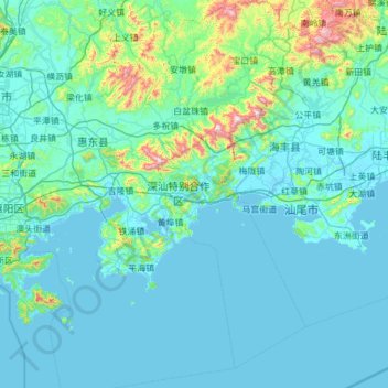
Name: Huidong County topographic map, elevation, terrain.

Location: Huidong County, Huizhou, Guangdong Province, China (22.26686 114.55395 23.38821 115.42155)

Average elevation: 325 ft

Minimum elevation: -7 ft

Maximum elevation: 3,930 ft

Other topographic maps

Click on a map to view its topography, its elevation and its terrain.

Baitang

China > Guangdong Province > Huizhou

Average elevation: 243 ft

Dipa

China > Guangdong Province > Huizhou

Average elevation: 1,037 ft

Gear up for your next adventure:

🪶Survival Guide Book - Expert advice for emergency preparedness
🪵Folding Camp Saw - Compact saw for wood and campsite work
Backpacking Tents - Weight-optimized shelters for multi-day topographic surveys
😴Insulated Sleeping Pads - Compact and warm pads for high-elevation camping
👖Convertible Hiking Pants - Versatile zip-off pants for changing altitudes and temperatures

As an Amazon Associate, this site earns from qualifying purchases at no extra cost to you.