
Thank you for supporting this site ❤️
Make a donation
Make a donation
Gear up for your next adventure:
As an Amazon Associate, this site earns from qualifying purchases at no extra cost to you.
Pedescala topographic map
Click on the map to display elevation.
Thank you for supporting this site ❤️
Make a donation
Make a donation
Gear up for your next adventure:
As an Amazon Associate, this site earns from qualifying purchases at no extra cost to you.
About this map
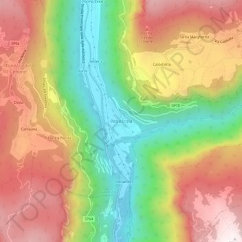
Name: Pedescala topographic map, elevation, terrain.
Location: Pedescala, Valdastico, Vicenza, Veneto, 36011, Italia (45.82847 11.35055 45.86847 11.39055)
Average elevation: 2,484 ft
Minimum elevation: 951 ft
Maximum elevation: 4,006 ft
Thank you for supporting this site ❤️
Make a donation
Make a donation
Gear up for your next adventure:
As an Amazon Associate, this site earns from qualifying purchases at no extra cost to you.