
County of Wetaskiwin topographic map
Interactive map
Click on the map to display elevation.
About this map
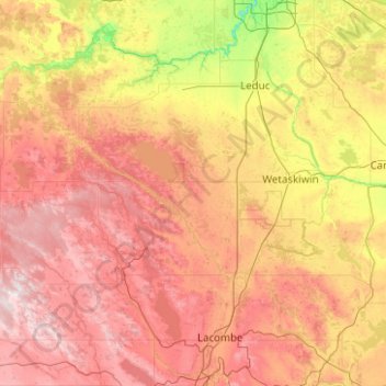
Name: County of Wetaskiwin topographic map, elevation, terrain.
Location: County of Wetaskiwin, Alberta, Canada (52.71306 -115.02582 53.13419 -113.02756)
Average elevation: 2,743 ft
Minimum elevation: 2,034 ft
Maximum elevation: 3,720 ft
Other topographic maps
Click on a map to view its topography, its elevation and its terrain.
Alder Flats
Canada > Alberta > County of Wetaskiwin
Alder Flats, County of Wetaskiwin, Alberta, Canada
Average elevation: 3,068 ft
Pigeon Lake
Canada > Alberta > County of Wetaskiwin > Summer Village of Golden Days
Pigeon Lake, Summer Village of Golden Days, County of Wetaskiwin, Alberta, Canada
Average elevation: 2,838 ft
Buck Lake
Canada > Alberta > County of Wetaskiwin > Buck Lake
Buck Lake, County of Wetaskiwin, Alberta, T0C 0T0, Canada
Average elevation: 2,956 ft
Pipestone
Canada > Alberta > County of Wetaskiwin
Pipestone, County of Wetaskiwin, Alberta, Canada
Average elevation: 2,608 ft