
Thank you for supporting this site ❤️
Make a donation
Make a donation
Gear up for your next adventure:
As an Amazon Associate, this site earns from qualifying purchases at no extra cost to you.
Maials topographic map
Click on the map to display elevation.
Thank you for supporting this site ❤️
Make a donation
Make a donation
Gear up for your next adventure:
As an Amazon Associate, this site earns from qualifying purchases at no extra cost to you.
About this map
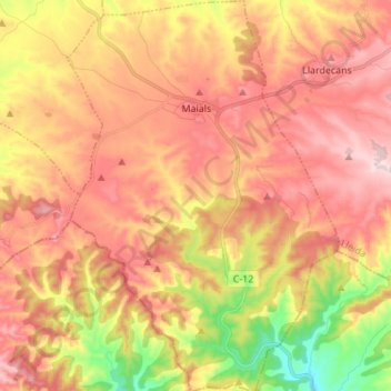
Name: Maials topographic map, elevation, terrain.
Location: Maials, Segrià, Lleida, Catalonië, 25179, Spanje (41.28973 0.46001 41.39229 0.55515)
Average elevation: 1,053 ft
Minimum elevation: 427 ft
Maximum elevation: 1,499 ft
Thank you for supporting this site ❤️
Make a donation
Make a donation
Gear up for your next adventure:
As an Amazon Associate, this site earns from qualifying purchases at no extra cost to you.