Geolocate

Split topographic map

Click on the map to display elevation.

About this map

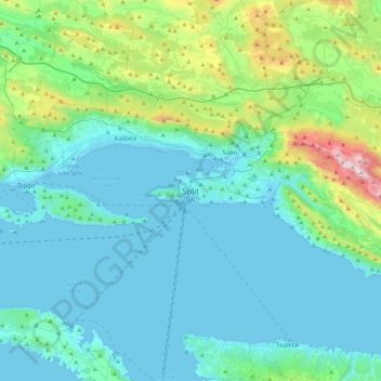
Name: Split topographic map, elevation, terrain.

Location: Split, Grad Split, Split-Dalmatia County, 21000, Croatia (43.35164 16.27997 43.67164 16.59997)

Average elevation: 673 ft

Minimum elevation: -10 ft

Maximum elevation: 4,344 ft

Gear up for your next adventure:

🥤Water Filter Bottle - All‑in‑one filter bottle for safe hydration
🌧️Backpack Rain Cover - Keep gear dry in wet weather
🎒Hydration Pack - Hands‑free water reservoir for long hikes
🪑Portable Camp Table - Compact table for campsite meals
Backpacking Tent - Lightweight and durable tent for multi‑day hikes

As an Amazon Associate, this site earns from qualifying purchases at no extra cost to you.