Geolocate

Pasig topographic map

Click on the map to display elevation.

About this map

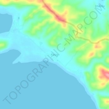
Name: Pasig topographic map, elevation, terrain.

Location: Pasig, Claveria, Masbate, Bicol Region, 5419, Philippines (12.87165 123.14332 12.91165 123.18332)

Average elevation: 72 ft

Minimum elevation: 0 ft

Maximum elevation: 367 ft

Gear up for your next adventure:

🛶Inflatable Kayak - Portable kayak for rivers, lakes, and expeditions
🦶Hiking Gaiters - Keep debris and water out of your boots
🚁Photography Drones - Capture stunning aerial views of landforms and topography
🧣Hiking Neck Gaiter - Multi‑use neck protection for outdoor weather
🧴Hand Sanitizer - Keep hands clean while hiking

As an Amazon Associate, this site earns from qualifying purchases at no extra cost to you.