
Make a donation
Gear up for your next adventure:
As an Amazon Associate, this site earns from qualifying purchases at no extra cost to you.
Cutro topographic map
Click on the map to display elevation.
Make a donation
Gear up for your next adventure:
As an Amazon Associate, this site earns from qualifying purchases at no extra cost to you.
About this map
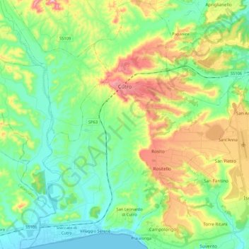
Name: Cutro topographic map, elevation, terrain.
Location: Cutro, Crotone, Calabria, 88842, Italia (38.92830 16.89053 39.09197 17.08566)
Average elevation: 289 ft
Minimum elevation: -7 ft
Maximum elevation: 889 ft
Make a donation
Gear up for your next adventure:
As an Amazon Associate, this site earns from qualifying purchases at no extra cost to you.
Other topographic maps
Click on a map to view its topography, its elevation and its terrain.
Make a donation
Gear up for your next adventure:
As an Amazon Associate, this site earns from qualifying purchases at no extra cost to you.
Capo Piccolo
Italia > Calabria > Crotone > Isola di Capo Rizzuto > Sant'Antonio
Average elevation: 49 ft