
Make a donation
Gear up for your next adventure:
As an Amazon Associate, this site earns from qualifying purchases at no extra cost to you.
Semmering topographic map
Click on the map to display elevation.
Make a donation
Gear up for your next adventure:
As an Amazon Associate, this site earns from qualifying purchases at no extra cost to you.
Semmering
Semmering is located on the border of Lower Austria and Styria at an elevation of 1,000 m (3,280 ft) above sea level and surrounded with forest. Semmering city is located in Neunkirchen, about 100 km (60 mi) from Vienna.
Make a donation
Gear up for your next adventure:
As an Amazon Associate, this site earns from qualifying purchases at no extra cost to you.
About this map
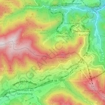
Name: Semmering topographic map, elevation, terrain.
Location: Semmering, Bezirk Neunkirchen, Lower Austria, 2680, Austria (47.61810 15.78132 47.65734 15.85002)
Average elevation: 3,284 ft
Minimum elevation: 2,142 ft
Maximum elevation: 4,596 ft
Make a donation
Gear up for your next adventure:
As an Amazon Associate, this site earns from qualifying purchases at no extra cost to you.