
Make a donation
Gear up for your next adventure:
As an Amazon Associate, this site earns from qualifying purchases at no extra cost to you.
Bourdasse topographic map
Click on the map to display elevation.
Make a donation
Gear up for your next adventure:
As an Amazon Associate, this site earns from qualifying purchases at no extra cost to you.
About this map
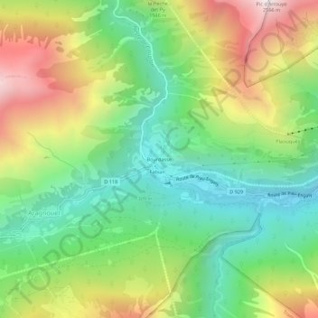
Name: Bourdasse topographic map, elevation, terrain.
Average elevation: 5,302 ft
Minimum elevation: 3,409 ft
Maximum elevation: 8,287 ft
Make a donation
Gear up for your next adventure:
As an Amazon Associate, this site earns from qualifying purchases at no extra cost to you.
Other topographic maps
Click on a map to view its topography, its elevation and its terrain.
Réserve naturelle du Néouvielle
France > Occitanie > Hautes-Pyrénées > Aragnouet > Soulan
La réserve naturelle nationale du Néouvielle (RNN4) est une réserve naturelle nationale située dans la région Occitanie. Créée en 1935 et classée en 1968, elle occupe une surface de 2 313 hectares au nord-est du Pic de Néouvielle dans le massif montagneux des Pyrénées. S'étageant entre 1 800 et 3…
Average elevation: 7,438 ft
Make a donation
Gear up for your next adventure:
As an Amazon Associate, this site earns from qualifying purchases at no extra cost to you.