Geolocate

Kanthalloor topographic map

Click on the map to display elevation.

About this map

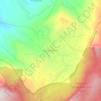
Name: Kanthalloor topographic map, elevation, terrain.

Location: Kanthalloor, Devikulam, Idukki, Kerala, India (10.19654 77.17555 10.23654 77.21555)

Average elevation: 5,118 ft

Minimum elevation: 3,219 ft

Maximum elevation: 7,211 ft

Other topographic maps

Click on a map to view its topography, its elevation and its terrain.

Munnar Town

India > Kerala > Devikulam > Munnar

Average elevation: 5,207 ft

Gear up for your next adventure:

🧭GPS Watch Accessories - Bands and chargers for GPS watches
🩳Quick‑Dry Hiking Shorts - Comfortable and quick‑dry shorts for summer hiking
📦Dry Bags Set - Waterproof storage for electronics and clothes
🧯Portable Fire Pit - Compact fire pit for camping spots
🧴Hand Sanitizer - Keep hands clean while hiking

As an Amazon Associate, this site earns from qualifying purchases at no extra cost to you.