
Make a donation
Gear up for your next adventure:
As an Amazon Associate, this site earns from qualifying purchases at no extra cost to you.
Bad Grönenbach topographic map
Click on the map to display elevation.
Make a donation
Gear up for your next adventure:
As an Amazon Associate, this site earns from qualifying purchases at no extra cost to you.
Bad Grönenbach
Der Ort liegt im Südwesten Bayerns, rund 13 Kilometer südlich der kreisfreien Stadt Memmingen in der Region Donau-Iller in Oberschwaben. Der Markt im südwestlichen Bereich des Landkreises Unterallgäu auf einer Höhe von 718 m ü. NHN und grenzt südlich an den Landkreis Oberallgäu, mit dem die typische Allgäuer Hügellandschaft beginnt. Die höchste Erhebung mit 841 m ü. NHN befindet sich im Südosten des Gemeindegebietes, etwa 1,4 km südsüdöstlich des Weilers Hintergsäng. Ungefähr ein Viertel des Gemeindegebiets ist mit Wald bedeckt, größtenteils der Grönenbacher Wald südwestlich des Hauptortes.
Make a donation
Gear up for your next adventure:
As an Amazon Associate, this site earns from qualifying purchases at no extra cost to you.
About this map
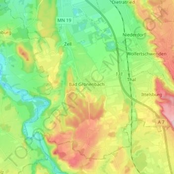
Name: Bad Grönenbach topographic map, elevation, terrain.
Average elevation: 2,287 ft
Minimum elevation: 1,991 ft
Maximum elevation: 2,753 ft
Make a donation
Gear up for your next adventure:
As an Amazon Associate, this site earns from qualifying purchases at no extra cost to you.
Other topographic maps
Click on a map to view its topography, its elevation and its terrain.
Bollenmühle
Deutschland > Bayern > Landkreis Unterallgäu > Ottobeuren > Ollarzried
Average elevation: 2,516 ft
Herbisried
Deutschland > Bayern > Landkreis Unterallgäu > Bad Grönenbach
Herbisried liegt in Oberschwaben in der Donau-Iller-Region, etwa drei Kilometer südlich von Bad Grönenbach, auf einer Höhe von 769 m ü. NN. An Herbisried grenzen im Uhrzeigersinn, im Norden beginnend, der Markt Bad Grönenbach, die Weiler Kornhofen, Hueb, Gmeinschwenden, Sommersberg und Greit. Mit Ausnahme…
Average elevation: 2,398 ft
Make a donation
Gear up for your next adventure:
As an Amazon Associate, this site earns from qualifying purchases at no extra cost to you.
Make a donation
Gear up for your next adventure:
As an Amazon Associate, this site earns from qualifying purchases at no extra cost to you.
Guggenberg
Deutschland > Bayern > Landkreis Unterallgäu > Ottobeuren
Ottobeuren | Bäuerle | Betzisried | Bibelsberg | Böglins | Boschach | Brüchlins | Bühl | Daßberg | Dennenberg | Eggisried | Eheim | Eheimer Mühle | Eldern | Fröhlins | Geislins | Guggenberg | Gumpratsried | Gut | Hahnenbühl | Haitzen | Halbersberg | Hessen | Höhe | Hofs | Kloster Wald | Langenberg |…
Average elevation: 2,283 ft
Make a donation
Gear up for your next adventure:
As an Amazon Associate, this site earns from qualifying purchases at no extra cost to you.
Halbersberg
Deutschland > Bayern > Landkreis Unterallgäu > Ottobeuren > Langenberg
Ottobeuren | Bäuerle | Betzisried | Bibelsberg | Böglins | Boschach | Brüchlins | Bühl | Daßberg | Dennenberg | Eggisried | Eheim | Eheimer Mühle | Eldern | Fröhlins | Geislins | Guggenberg | Gumpratsried | Gut | Hahnenbühl | Haitzen | Halbersberg | Hessen | Höhe | Hofs | Kloster Wald | Langenberg |…
Average elevation: 2,270 ft
Make a donation
Gear up for your next adventure:
As an Amazon Associate, this site earns from qualifying purchases at no extra cost to you.
Brüchlins
Deutschland > Bayern > Landkreis Unterallgäu > Ottobeuren
Ottobeuren | Bäuerle | Betzisried | Bibelsberg | Böglins | Boschach | Brüchlins | Bühl | Daßberg | Dennenberg | Eggisried | Eheim | Eheimer Mühle | Eldern | Fröhlins | Geislins | Guggenberg | Gumpratsried | Gut | Hahnenbühl | Haitzen | Halbersberg | Hessen | Höhe | Hofs | Kloster Wald | Langenberg |…
Average elevation: 2,221 ft
Make a donation
Gear up for your next adventure:
As an Amazon Associate, this site earns from qualifying purchases at no extra cost to you.
Make a donation
Gear up for your next adventure:
As an Amazon Associate, this site earns from qualifying purchases at no extra cost to you.
Gmeinschwenden
Deutschland > Bayern > Landkreis Unterallgäu > Bad Grönenbach
Das Dorf liegt etwa drei Kilometer südlich von Bad Grönenbach auf einer Höhe von 750 m ü. NN. Die Landkreisgrenze zwischen Unterallgäu und Oberallgäu verläuft unmittelbar südlich des Dorfes. Gmeinschwenden grenzt im Norden an das Dorf Herbisried, sowie im weiteren Verlauf im Uhrzeigersinn an die Weiler…
Average elevation: 2,382 ft
Make a donation
Gear up for your next adventure:
As an Amazon Associate, this site earns from qualifying purchases at no extra cost to you.
Make a donation
Gear up for your next adventure:
As an Amazon Associate, this site earns from qualifying purchases at no extra cost to you.
Schlingen
Deutschland > Bayern > Landkreis Unterallgäu > Bad Wörishofen
Das Pfarrdorf Schlingen liegt westlich der Wertach auf einer Höhe von 642 m ü. NHN, umfasst ein Gebiet von rund 13,37 Quadratkilometer und hatte im Dezember 2021 746 Einwohner.
Average elevation: 2,116 ft
Make a donation
Gear up for your next adventure:
As an Amazon Associate, this site earns from qualifying purchases at no extra cost to you.
Dietratried
Deutschland > Bayern > Landkreis Unterallgäu
Das Kirchdorf Dietratried liegt drei Kilometer nordwestlich von Wolfertschwenden, auf einer Höhe von 651 m ü. NN.
Average elevation: 2,231 ft
Make a donation
Gear up for your next adventure:
As an Amazon Associate, this site earns from qualifying purchases at no extra cost to you.
Greimeltshofen
Deutschland > Bayern > Landkreis Unterallgäu > Greimeltshofen
Average elevation: 1,936 ft
Stockheim
Deutschland > Bayern > Landkreis Unterallgäu > Bad Wörishofen > Stockheim
Average elevation: 2,064 ft
Griesthal
Deutschland > Bayern > Landkreis Unterallgäu > Markt Rettenbach > Griesthal
Average elevation: 2,490 ft
Make a donation
Gear up for your next adventure:
As an Amazon Associate, this site earns from qualifying purchases at no extra cost to you.
Make a donation
Gear up for your next adventure:
As an Amazon Associate, this site earns from qualifying purchases at no extra cost to you.
Make a donation
Gear up for your next adventure:
As an Amazon Associate, this site earns from qualifying purchases at no extra cost to you.