
Cibingbin topographic map
Click on the map to display elevation.
About this map
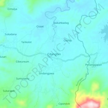
Name: Cibingbin topographic map, elevation, terrain.
Location: Cibingbin, Kuningan, West Java, Java, Indonesia (-7.09477 108.71853 -7.01477 108.79853)
Average elevation: 404 ft
Minimum elevation: 118 ft
Maximum elevation: 2,388 ft
Other topographic maps
Click on a map to view its topography, its elevation and its terrain.
Gunung Ciremai National Park
Indonesia > West Java > Kuningan > Padabeunghar
Average elevation: 2,881 ft