Geolocate

Cikadu topographic map

Click on the map to display elevation.

About this map

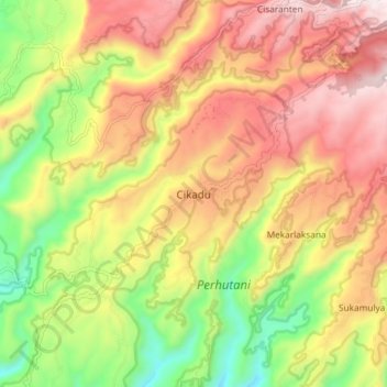
Name: Cikadu topographic map, elevation, terrain.

Location: Cikadu, Cianjur, West Java, Java, Indonesia (-7.36277 107.21644 -7.28277 107.29644)

Average elevation: 2,051 ft

Minimum elevation: 627 ft

Maximum elevation: 3,373 ft

Other topographic maps

Click on a map to view its topography, its elevation and its terrain.

Kertajadi

Indonesia > West Java > Cianjur

Average elevation: 354 ft

Agrabinta

Indonesia > West Java > Cianjur

Average elevation: 354 ft

Cidaun

Indonesia > West Java > Cianjur

Average elevation: 2,159 ft

Karangwangi

Indonesia > West Java > Cianjur

Average elevation: 390 ft

Wanasari

Indonesia > West Java > Cianjur

Average elevation: 102 ft

Jayapura

Indonesia > West Java > Cianjur

Average elevation: 240 ft

Cisalak

Indonesia > West Java > Cianjur

Average elevation: 161 ft

Gear up for your next adventure:

🪑Portable Camp Table - Compact table for campsite meals
🧯Portable Fire Pit - Compact fire pit for camping spots
🪶Fire Starter Kit - Reliable fire starter for survival and camping
🧦Merino Wool Socks - Moisture-wicking, blister-preventing socks for long treks
🧭Map Reading Tools - Tools and kits for map navigation

As an Amazon Associate, this site earns from qualifying purchases at no extra cost to you.