Geolocate

Tilton topographic map

Click on the map to display elevation.

About this map

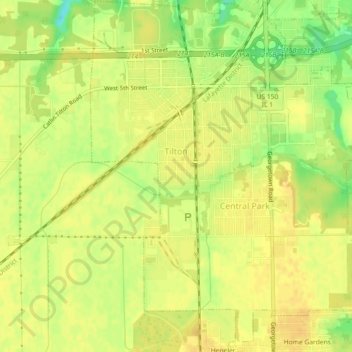
Name: Tilton topographic map, elevation, terrain.

Location: Tilton, Vermilion County, Illinois, 61833, United States (40.07556 -87.65854 40.11012 -87.61988)

Average elevation: 646 ft

Minimum elevation: 581 ft

Maximum elevation: 669 ft

Vermilion County trails, hiking, mountain biking, running and outdoor activities

Other topographic maps

Click on a map to view its topography, its elevation and its terrain.

Alvin

United States > Illinois > Vermilion County

Average elevation: 673 ft

Brooks Point

United States > Illinois > Vermilion County

Average elevation: 617 ft

Salt Fork

United States > Illinois > Vermilion County

Average elevation: 679 ft

Gear up for your next adventure:

🧺Microfiber Travel Towels - Compact and fast-drying towels for trail use
🛰️Satellite Messengers - Emergency SOS and two-way messaging for off-grid adventures
🌡️Portable Weather Meter - Track weather conditions on the trail
🥤Water Filter Bottle - All‑in‑one filter bottle for safe hydration
🧭Orienteering Set - Complete compass and map reading kit

As an Amazon Associate, this site earns from qualifying purchases at no extra cost to you.