
Make a donation
Gear up for your next adventure:
As an Amazon Associate, this site earns from qualifying purchases at no extra cost to you.
Seixal topographic map
Click on the map to display elevation.
Make a donation
Gear up for your next adventure:
As an Amazon Associate, this site earns from qualifying purchases at no extra cost to you.
Seixal
Although the municipal population continued to grow with development, after the 1970s there was a boom in the population, due to improvements in accessibility and mobility, principally due to public transport, its location to Lisbon and installation of economic activities within the territory. This growth transformed, in a short time, from a territory predominantly rural into an urban municipality, consisting of agglomerations of large dimensions focusing on various establishments and social centres. This growth resulted in the 1993 elevation of Seixal and Amora into cities, and the establishment of Corroios into the status of town.
Make a donation
Gear up for your next adventure:
As an Amazon Associate, this site earns from qualifying purchases at no extra cost to you.
About this map
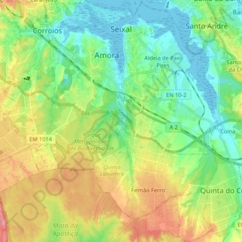
Name: Seixal topographic map, elevation, terrain.
Location: Seixal, Setúbal, Portugal (38.54068 -9.17835 38.65588 -9.04776)
Average elevation: 125 ft
Minimum elevation: -10 ft
Maximum elevation: 344 ft
Make a donation
Gear up for your next adventure:
As an Amazon Associate, this site earns from qualifying purchases at no extra cost to you.
Other topographic maps
Click on a map to view its topography, its elevation and its terrain.
Make a donation
Gear up for your next adventure:
As an Amazon Associate, this site earns from qualifying purchases at no extra cost to you.