Geolocate

Kahl am Main topographic map

Click on the map to display elevation.

About this map

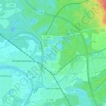
Name: Kahl am Main topographic map, elevation, terrain.

Location: Kahl am Main, Landkreis Aschaffenburg, Bavaria, 63796, Germany (50.05912 8.98805 50.11426 9.03655)

Average elevation: 377 ft

Minimum elevation: 335 ft

Maximum elevation: 541 ft

Other topographic maps

Click on a map to view its topography, its elevation and its terrain.

Pflaumheim

Germany > Bavaria > Landkreis Aschaffenburg

Average elevation: 531 ft

Großostheim

Germany > Bavaria > Landkreis Aschaffenburg

Average elevation: 486 ft

Heimbach

Germany > Bavaria > Landkreis Aschaffenburg

Average elevation: 850 ft

Wasserlos

Germany > Bavaria > Landkreis Aschaffenburg

Average elevation: 607 ft

Gear up for your next adventure:

Backpacking Tents - Weight-optimized shelters for multi-day topographic surveys
🪶Thermal Camp Blanket - Extra warmth for cold nights
🏕️Tent Footprint - Protect your tent base from wear
🪶LED Camping Lantern - Bright lantern for camp lighting
📦Dry Bags Set - Waterproof storage for electronics and clothes

As an Amazon Associate, this site earns from qualifying purchases at no extra cost to you.