
Thank you for supporting this site ❤️
Make a donation
Make a donation
Gear up for your next adventure:
As an Amazon Associate, this site earns from qualifying purchases at no extra cost to you.
Cerquedo topographic map
Click on the map to display elevation.
Thank you for supporting this site ❤️
Make a donation
Make a donation
Gear up for your next adventure:
As an Amazon Associate, this site earns from qualifying purchases at no extra cost to you.
About this map
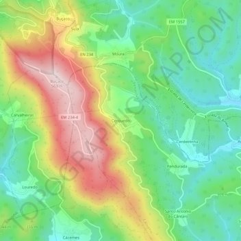
Name: Cerquedo topographic map, elevation, terrain.
Location: Cerquedo, Carvalho, Penacova, Coimbra, 3050-224, Portugal (40.34133 -8.36453 40.38133 -8.32453)
Average elevation: 1,060 ft
Minimum elevation: 551 ft
Maximum elevation: 1,854 ft
Thank you for supporting this site ❤️
Make a donation
Make a donation
Gear up for your next adventure:
As an Amazon Associate, this site earns from qualifying purchases at no extra cost to you.