
Bloemfontein topographic map
Click on the map to display elevation.
Bloemfontein
Situated at an elevation of 1,395 m (4,577 ft) above sea level, the city is home to 256,185 (as of 2011) residents and forms part of the Mangaung Metropolitan Municipality which has a population of 747,431. It was one of the host cities for the 2010 FIFA World Cup.
About this map
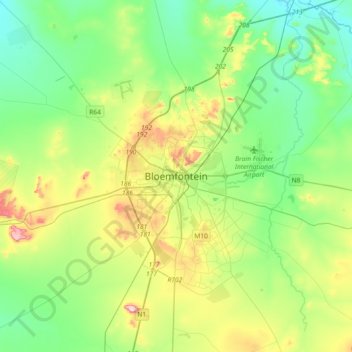
Name: Bloemfontein topographic map, elevation, terrain.
Average elevation: 4,508 ft
Minimum elevation: 4,209 ft
Maximum elevation: 5,226 ft
Other topographic maps
Click on a map to view its topography, its elevation and its terrain.
Klein-Modder
South Africa > Free State > Mangaung Metropolitan Municipality > Botshabelo
Average elevation: 4,567 ft
Mangaung Ward 26
South Africa > Free State > Mangaung Metropolitan Municipality
Average elevation: 4,390 ft
Rustfontein Dam
South Africa > Free State > Mangaung Metropolitan Municipality
Average elevation: 4,511 ft
Mangaung Ward 12
South Africa > Free State > Mangaung Metropolitan Municipality > Bloemfontein
Average elevation: 4,587 ft
Bloemspruit
South Africa > Free State > Mangaung Metropolitan Municipality > Bloemfontein
Average elevation: 4,514 ft
Wag-n'-Bietjie Park
South Africa > Free State > Mangaung Metropolitan Municipality > Bloemfontein
Average elevation: 4,629 ft