Geolocate

Crawford topographic map

Click on the map to display elevation.

About this map

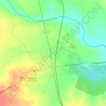
Name: Crawford topographic map, elevation, terrain.

Location: Crawford, McLennan County, Texas, United States (31.52379 -97.46434 31.55538 -97.41533)

Average elevation: 689 ft

Minimum elevation: 600 ft

Maximum elevation: 794 ft

McLennan County trails, hiking, mountain biking, running and outdoor activities

Other topographic maps

Click on a map to view its topography, its elevation and its terrain.

Wiggins

United States > Texas > McLennan County

Average elevation: 564 ft

Waco

United States > Texas > McLennan County > Waco

Average elevation: 492 ft

McGregor

United States > Texas > McLennan County > McGregor > McGregor

Average elevation: 715 ft

Speegleville

United States > Texas > McLennan County > Waco

Average elevation: 495 ft

Bruceville-Eddy

United States > Texas > McLennan County

Average elevation: 650 ft

Eddy

United States > Texas > McLennan County > Bruceville-Eddy

Average elevation: 692 ft

Tehuacana Creek

United States > Texas > McLennan County > Neale

Average elevation: 394 ft

Bosqueville

United States > Texas > McLennan County > Waco > Bosqueville

Average elevation: 443 ft

Gear up for your next adventure:

🧷Carabiner Set - Durable clips for gear attachment
🎁Geography Themed Gifts - Unique gift ideas for map lovers and geography enthusiasts
🪶Wildlife Field Guides - Learn animal tracking and species ID
📱Heavy-Duty Phone Cases - Drop-proof and waterproof protection for outdoor navigation
🎒Outdoor Daypacks - Lightweight backpacks designed for carrying maps and essential gear

As an Amazon Associate, this site earns from qualifying purchases at no extra cost to you.