Geolocate

Elk Ridge topographic map

Click on the map to display elevation.

About this map

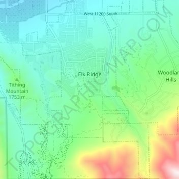
Name: Elk Ridge topographic map, elevation, terrain.

Location: Elk Ridge, Utah County, Utah, United States (39.98373 -111.70111 40.03084 -111.65627)

Average elevation: 5,571 ft

Minimum elevation: 4,738 ft

Maximum elevation: 8,146 ft

Utah County trails, hiking, mountain biking, running and outdoor activities

Other topographic maps

Click on a map to view its topography, its elevation and its terrain.

Townsend

United States > Utah > Utah County > Genola

Average elevation: 4,718 ft

Aspen Grove

United States > Utah > Utah County

Average elevation: 7,736 ft

Olmsted

United States > Utah > Utah County > Orem

Average elevation: 5,230 ft

Bicentennial Park

United States > Utah > Utah County > Provo

Average elevation: 4,810 ft

Lehi

United States > Utah > Utah County > Lehi

Average elevation: 5,518 ft

Birdseye

United States > Utah > Utah County

Average elevation: 5,840 ft

Geneva

United States > Utah > Utah County > Orem > Geneva

Average elevation: 4,564 ft

Deer Creek

United States > Utah > Utah County

Average elevation: 6,991 ft

Edgemont

United States > Utah > Utah County > Provo

Average elevation: 5,046 ft

Gear up for your next adventure:

🧭Compass with Lanyard - Easy‑carry compass for navigation
🛌Ultralight Sleeping Bags - Compact down bags for cold nights in the wilderness
📡GPS Antenna Upgrade - Enhance GPS reception in remote terrain
🛰️Handheld GPS Units - Professional satellite navigators for precise backcountry mapping
🧦Merino Wool Socks - Moisture-wicking, blister-preventing socks for long treks

As an Amazon Associate, this site earns from qualifying purchases at no extra cost to you.