
Make a donation
Gear up for your next adventure:
As an Amazon Associate, this site earns from qualifying purchases at no extra cost to you.
Taiarapu-Est topographic map
Click on the map to display elevation.
Make a donation
Gear up for your next adventure:
As an Amazon Associate, this site earns from qualifying purchases at no extra cost to you.
About this map
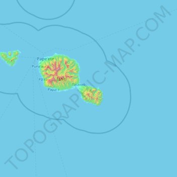
Name: Taiarapu-Est topographic map, elevation, terrain.
Location: Taiarapu-Est, Îles du Vent, Polynésie française, France (-17.88342 -149.41307 -17.62960 -148.05971)
Average elevation: 82 ft
Minimum elevation: 0 ft
Maximum elevation: 6,762 ft
Make a donation
Gear up for your next adventure:
As an Amazon Associate, this site earns from qualifying purchases at no extra cost to you.
Other topographic maps
Click on a map to view its topography, its elevation and its terrain.
Make a donation
Gear up for your next adventure:
As an Amazon Associate, this site earns from qualifying purchases at no extra cost to you.
Belvédère de Taravao
France > Polynésie française > Îles du Vent > Taiarapu-Est
Average elevation: 1,726 ft
Make a donation
Gear up for your next adventure:
As an Amazon Associate, this site earns from qualifying purchases at no extra cost to you.