
Make a donation
Gear up for your next adventure:
As an Amazon Associate, this site earns from qualifying purchases at no extra cost to you.
Qonaev topographic map
Click on the map to display elevation.
Make a donation
Gear up for your next adventure:
As an Amazon Associate, this site earns from qualifying purchases at no extra cost to you.
About this map
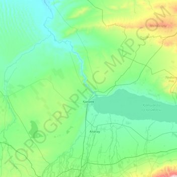
Name: Qonaev topographic map, elevation, terrain.
Location: Qonaev, Almaty Region, 040800, Kazakhstan (43.70123 76.93365 44.18949 78.49939)
Average elevation: 2,096 ft
Minimum elevation: 1,348 ft
Maximum elevation: 7,379 ft
Make a donation
Gear up for your next adventure:
As an Amazon Associate, this site earns from qualifying purchases at no extra cost to you.
Other topographic maps
Click on a map to view its topography, its elevation and its terrain.
Talgar
Kazakhstan > Almaty Region > Talgar District
Talgar has a total area of 18.8 square km (7.3 mi²). The grade of the town's built-up areas is consistent with the natural unevenness of its overall natural geography. The average land elevation is 1250 m above sea level. The lowest points are in the northern part of the town at 1000 m, while the highest…
Average elevation: 3,215 ft