
Kilbourn topographic map
Click on the map to display elevation.
About this map
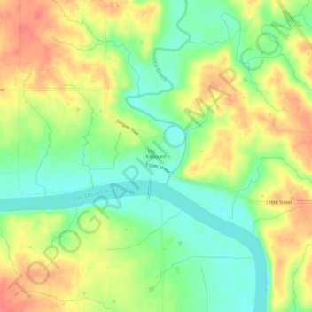
Name: Kilbourn topographic map, elevation, terrain.
Location: Kilbourn, Van Buren County, Iowa, United States (40.78431 -91.98931 40.82431 -91.94931)
Average elevation: 656 ft
Minimum elevation: 568 ft
Maximum elevation: 748 ft
Van Buren County trails, hiking, mountain biking, running and outdoor activities
Other topographic maps
Click on a map to view its topography, its elevation and its terrain.
Keosauqua
United States > Iowa > Van Buren County
Keosauqua is in the Southern Iowa Drift Plain, formed by Pre-Illinoian glaciers approximately 300,000 years ago. The topography of the area is heavily forested rolling hills, interspersed with farmland, and has many tributaries flowing into the Des Moines River. The Des Moines was large enough to handle…
Average elevation: 630 ft
Shimek State Forest - Farmington Unit
United States > Iowa > Van Buren County
Average elevation: 673 ft