Geolocate

Prince topographic map

Click on the map to display elevation.

About this map

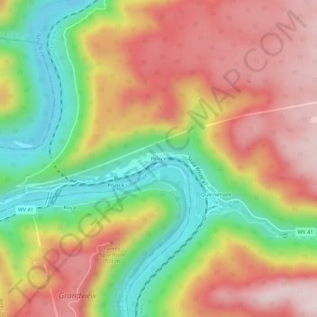
Name: Prince topographic map, elevation, terrain.

Location: Prince, Fayette County, West Virginia, 26907, United States (37.83900 -81.07371 37.87900 -81.03371)

Average elevation: 1,883 ft

Minimum elevation: 1,079 ft

Maximum elevation: 2,631 ft

Fayette County trails, hiking, mountain biking, running and outdoor activities

Other topographic maps

Click on a map to view its topography, its elevation and its terrain.

Ansted

United States > West Virginia > Fayette County

Average elevation: 1,572 ft

Powellton

United States > West Virginia > Fayette County

Average elevation: 1,552 ft

Smithers

United States > West Virginia > Fayette County

Average elevation: 1,119 ft

Pax

United States > West Virginia > Fayette County

Average elevation: 1,821 ft

Montgomery

United States > West Virginia > Fayette County

Average elevation: 1,106 ft

Gear up for your next adventure:

📶Vehicle Signal Boosters - Improve reception in rural areas while driving to trailheads
🔭Compact Binoculars - HD vision for scouting terrain and identifying distant landmarks
📚USA Hiking Guide Books - Top trail guides and map books
📦Dry Bags Set - Waterproof storage for electronics and clothes
🧭Pro Hiking Compasses - High-accuracy liquid-filled compasses for topographic orientation

As an Amazon Associate, this site earns from qualifying purchases at no extra cost to you.