
Make a donation
Gear up for your next adventure:
As an Amazon Associate, this site earns from qualifying purchases at no extra cost to you.
Sidon topographic map
Click on the map to display elevation.
Make a donation
Gear up for your next adventure:
As an Amazon Associate, this site earns from qualifying purchases at no extra cost to you.
Sidon
The city of Sidon is administrated by the Municipality of Sidon. The municipality is constituted of a council of 21 members including the City Mayor and his Deputy. It has administrative and financial independence but remains under the control and supervision of the central government, specifically the Ministry of Interior. The municipality's jurisdiction is limited to a region of 786 hectares in area and 5 meters in elevation, while each of the city's suburbs is administrated by its own independent municipal council. Sidon is the center of the Governorate of South Lebanon, and hosts the seat of the Governor of Southern Lebanon. The city is also the center of the Sidon District and the Union of Sidon and Zahrani Municipalities (founded in 1978 and contains 15 municipalities). Sidon hosts the southern regional headquarters of a series of governmental facilities like the Central Bank of Lebanon, Électricité du Liban, Central Telecommunications Station and others. It is also the home of the Justice Palace of South Lebanon in its new headquarters on East Boulevard (the old headquarters were an old Ottoman Saray that is currently occupied by the LSF and is planned to be transformed into a cultural center by the municipality).
Make a donation
Gear up for your next adventure:
As an Amazon Associate, this site earns from qualifying purchases at no extra cost to you.
About this map
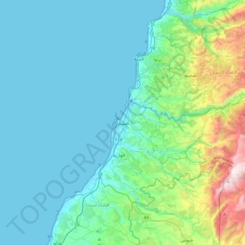
Name: Sidon topographic map, elevation, terrain.
Average elevation: 755 ft
Minimum elevation: 0 ft
Maximum elevation: 4,616 ft
Make a donation
Gear up for your next adventure:
As an Amazon Associate, this site earns from qualifying purchases at no extra cost to you.
Other topographic maps
Click on a map to view its topography, its elevation and its terrain.
Sidon
The city of Sidon is administered by the Municipality of Sidon. The municipality is constituted of a council of 21 members including the City Mayor and his Deputy. It has administrative and financial independence but remains under the control and supervision of the central government, specifically the Ministry…
Average elevation: 125 ft
Make a donation
Gear up for your next adventure:
As an Amazon Associate, this site earns from qualifying purchases at no extra cost to you.
Sidon
The city of Sidon is administered by the Municipality of Sidon. The municipality is constituted of a council of 21 members including the City Mayor and his Deputy. It has administrative and financial independence but remains under the control and supervision of the central government, specifically the Ministry…
Average elevation: 144 ft
Make a donation
Gear up for your next adventure:
As an Amazon Associate, this site earns from qualifying purchases at no extra cost to you.
Make a donation
Gear up for your next adventure:
As an Amazon Associate, this site earns from qualifying purchases at no extra cost to you.
Tyre
Since 2008, a Lebanese-French team under the direction by Pierre-Louis Gatier of the University of Lyon has been conducting archaeological and topographical work. When international archeological missions in Syria came to a halt after 2012 due to the war there, some of them instead started excavations in Tyre,…
Average elevation: 16 ft
Make a donation
Gear up for your next adventure:
As an Amazon Associate, this site earns from qualifying purchases at no extra cost to you.
Tyre
Since 2008, a Lebanese French team under the direction by Pierre-Louis Gatier of the University of Lyon has been conducting archaeological and topographical work. When international archeological missions in Syria came to a halt after 2012 due to the war there, some of them instead started excavations in Tyre,…
Average elevation: 16 ft