
Hinkle topographic map
Interactive map
Click on the map to display elevation.
About this map
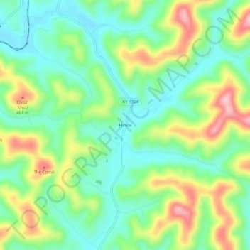
Name: Hinkle topographic map, elevation, terrain.
Location: Hinkle, Knox County, Kentucky, 40915, United States (36.89259 -83.83881 36.93259 -83.79881)
Average elevation: 1,207 ft
Minimum elevation: 978 ft
Maximum elevation: 1,614 ft
Other topographic maps
Click on a map to view its topography, its elevation and its terrain.
Walker
United States > Kentucky > Knox County
Walker, Knox County, Kentucky, 40997, United States
Average elevation: 1,322 ft
Flat Lick
United States > Kentucky > Knox County
Flat Lick, Knox County, Kentucky, 40935, United States
Average elevation: 1,145 ft
Big Rock
United States > Kentucky > Knox County
Big Rock, Knox County, Kentucky, 40923, United States
Average elevation: 1,165 ft
Barbourville
United States > Kentucky > Knox County
Barbourville, Knox County, Kentucky, 40906, United States
Average elevation: 1,060 ft
Baughman
United States > Kentucky > Knox County > Baughman
Baughman, Knox County, Kentucky, 40915, United States
Average elevation: 1,181 ft