
Make a donation
Gear up for your next adventure:
As an Amazon Associate, this site earns from qualifying purchases at no extra cost to you.
Hrabušice topographic map
Click on the map to display elevation.
Make a donation
Gear up for your next adventure:
As an Amazon Associate, this site earns from qualifying purchases at no extra cost to you.
Hrabušice
The village lies at an altitude of 548 metres and covers an area of 40.886 km². In 2011 Hrabušice had a population of about 2,378 inhabitants.
Make a donation
Gear up for your next adventure:
As an Amazon Associate, this site earns from qualifying purchases at no extra cost to you.
About this map
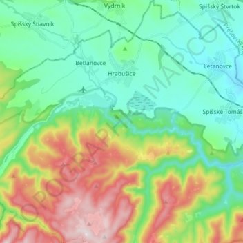
Name: Hrabušice topographic map, elevation, terrain.
Average elevation: 2,201 ft
Minimum elevation: 1,634 ft
Maximum elevation: 3,442 ft
Make a donation
Gear up for your next adventure:
As an Amazon Associate, this site earns from qualifying purchases at no extra cost to you.
Other topographic maps
Click on a map to view its topography, its elevation and its terrain.
Suchá Belá
Slovakia > Region of Košice > District of Spišská Nová Ves > Hrabušice
Average elevation: 2,562 ft