Geolocate

Front Royal topographic map

Click on the map to display elevation.

About this map

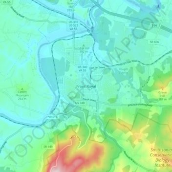
Name: Front Royal topographic map, elevation, terrain.

Location: Front Royal, Warren County, Virginia, United States (38.87785 -78.23177 38.95785 -78.15177)

Average elevation: 722 ft

Minimum elevation: 433 ft

Maximum elevation: 1,883 ft

Warren County trails, hiking, mountain biking, running and outdoor activities

Gear up for your next adventure:

Camping Coffee Makers - Enjoy premium coffee at the summit or campsite
❄️Traction Cleats - Prevent slips on icy trails during winter hikes
🦶Carbon Trekking Poles - Reduce knee impact on steep descents with ultra-light poles
🔭Stargazing Telescopes - Perfect for camping in low-light pollution areas shown on maps
🧥Men's Rain Shells - Premium waterproof and breathable jackets for mountain weather

As an Amazon Associate, this site earns from qualifying purchases at no extra cost to you.