Geolocate

Sempala topographic map

Click on the map to display elevation.

About this map

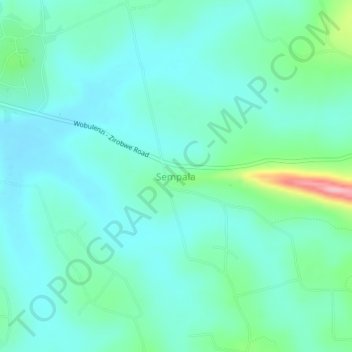
Name: Sempala topographic map, elevation, terrain.

Location: Sempala, Luweero, Central Region, Uganda (0.68671 32.53447 0.72671 32.57447)

Average elevation: 3,776 ft

Minimum elevation: 3,675 ft

Maximum elevation: 4,193 ft

Gear up for your next adventure:

🎒Gear Packing Cubes - Organize your backpack efficiently
🛡️Bear Spray Outdoor - Protection in bear country hikes
🎒Trekking Poles - Sturdy poles for balance and stability on rough terrain
📡Handheld GPS Device - Reliable handheld GPS for outdoor navigation
🧥Men's Rain Shells - Premium waterproof and breathable jackets for mountain weather

As an Amazon Associate, this site earns from qualifying purchases at no extra cost to you.