
Make a donation
Gear up for your next adventure:
As an Amazon Associate, this site earns from qualifying purchases at no extra cost to you.
La Batarelle topographic map
Click on the map to display elevation.
Make a donation
Gear up for your next adventure:
As an Amazon Associate, this site earns from qualifying purchases at no extra cost to you.
About this map
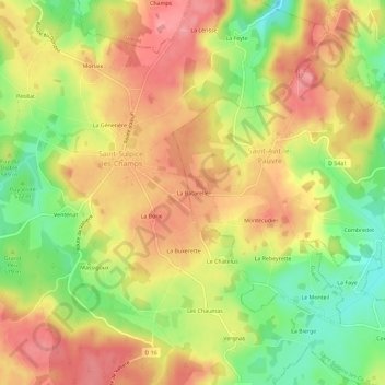
Name: La Batarelle topographic map, elevation, terrain.
Average elevation: 1,890 ft
Minimum elevation: 1,709 ft
Maximum elevation: 2,028 ft
Make a donation
Gear up for your next adventure:
As an Amazon Associate, this site earns from qualifying purchases at no extra cost to you.
Other topographic maps
Click on a map to view its topography, its elevation and its terrain.
Saint-Avit-le-Pauvre
France > Nouvelle-Aquitaine > Creuse > Saint-Avit-le-Pauvre
Le climat qui caractérise la commune est qualifié, en 2010, de « climat des marges montargnardes », selon la typologie des climats de la France qui compte alors huit grands types de climats en métropole. En 2020, la commune ressort du type « climat de montagne » dans la classification établie par…
Average elevation: 1,883 ft