
Dayuan District topographic map
Interactive map
Click on the map to display elevation.
About this map
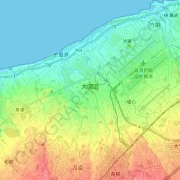
Name: Dayuan District topographic map, elevation, terrain.
Location: Dayuan District, Taoyuan City, Taiwan (25.00098 121.15205 25.12110 121.27322)
Average elevation: 118 ft
Minimum elevation: -7 ft
Maximum elevation: 377 ft
Dayuan District has an inclining topography from southwest to northwest with an average height of 35 meters above sea level. Inland area are mostly plains, rice fields or spacious flat lands, while in the northeast part is the prolonged sand beach seacoast.
Other topographic maps
Click on a map to view its topography, its elevation and its terrain.
Shangnanzi
Taiwan > Taoyuan City > Dayuan District
Shangnanzi, Hengfeng Village, Dayuan District, Taoyuan City, 33744, Taiwan
Average elevation: 121 ft
Luzhu District
Luzhu District, Taoyuan City, 338, Taiwan
Average elevation: 331 ft
營頭厝
Taiwan > Taoyuan City > Zhongli District > 營頭厝
營頭厝, Ren'ai Village, Zhongli District, Taoyuan City, 32083, Taiwan
Average elevation: 453 ft