
Daxi District topographic map
Interactive map
Click on the map to display elevation.
About this map
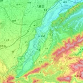
Name: Daxi District topographic map, elevation, terrain.
Location: Daxi District, Taoyuan City, Taiwan (24.80341 121.24311 24.93847 121.35812)
Average elevation: 728 ft
Minimum elevation: 95 ft
Maximum elevation: 2,073 ft
Other topographic maps
Click on a map to view its topography, its elevation and its terrain.
Shangnanzi
Taiwan > Taoyuan City > Dayuan District
Shangnanzi, Hengfeng Village, Dayuan District, Taoyuan City, 33744, Taiwan
Average elevation: 121 ft
Luzhu District
Luzhu District, Taoyuan City, 338, Taiwan
Average elevation: 331 ft
營頭厝
Taiwan > Taoyuan City > Zhongli District > 營頭厝
營頭厝, Ren'ai Village, Zhongli District, Taoyuan City, 32083, Taiwan
Average elevation: 453 ft