Geolocate

Kotor topographic map

Click on the map to display elevation.

About this map

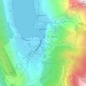
Name: Kotor topographic map, elevation, terrain.

Location: Kotor, Kotor Municipality, 85339, Montenegro (42.40840 18.75726 42.43247 18.77498)

Average elevation: 919 ft

Minimum elevation: -3 ft

Maximum elevation: 3,507 ft

Other topographic maps

Click on a map to view its topography, its elevation and its terrain.

Dub

Montenegro > Kotor Municipality > Sutvara

Average elevation: 741 ft

Dobrota

Montenegro > Kotor Municipality

Average elevation: 1,493 ft

Gear up for your next adventure:

🧭Map Reading Tools - Tools and kits for map navigation
🛏️Cold Weather Sleeping Bag - Warm sleeping bag for cold conditions
Camping Coffee Makers - Enjoy premium coffee at the summit or campsite
🧷Carabiner Set - Durable clips for gear attachment
🌄Hiking Binoculars - Compact binoculars for scenic views and trail spotting

As an Amazon Associate, this site earns from qualifying purchases at no extra cost to you.