Geolocate

Naval topographic map

Click on the map to display elevation.

About this map
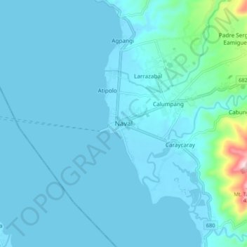
Name: Naval topographic map, elevation, terrain.

Location: Naval, Biliran, Eastern Visayas, 6543, Philippines (11.52179 124.35653 11.60179 124.43653)

Average elevation: 102 ft

Minimum elevation: -3 ft

Maximum elevation: 1,293 ft

Other topographic maps

Click on a map to view its topography, its elevation and its terrain.

Biliran

Philippines > Biliran

Average elevation: 558 ft

Maripipi

Philippines > Biliran

Average elevation: 171 ft

Anas River

Philippines > Biliran > Larrazabal

Average elevation: 656 ft

Sambawan Islands

Philippines > Biliran > Maripipi

Average elevation: 0 ft

Biliran

Philippines > Biliran

Average elevation: 558 ft

Gear up for your next adventure:

🎒Hydration Pack - Hands‑free water reservoir for long hikes
📚USA Hiking Guide Books - Top trail guides and map books
🔪Outdoor Multitools - Essential survival tools for gear repair and field use
🥾Men's Hiking Boots - Durable, waterproof footwear for rugged terrain and steep inclines
🕶️GPS Smartphone Mount - Secure mount for phone navigation

As an Amazon Associate, this site earns from qualifying purchases at no extra cost to you.