
Make a donation
Gear up for your next adventure:
As an Amazon Associate, this site earns from qualifying purchases at no extra cost to you.
Wetterfeld topographic map
Click on the map to display elevation.
Make a donation
Gear up for your next adventure:
As an Amazon Associate, this site earns from qualifying purchases at no extra cost to you.
About this map
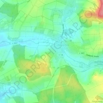
Name: Wetterfeld topographic map, elevation, terrain.
Location: Wetterfeld, Laubach, Landkreis Gießen, Hessen, Deutschland (50.53070 8.92675 50.56091 8.97499)
Average elevation: 696 ft
Minimum elevation: 604 ft
Maximum elevation: 886 ft
Make a donation
Gear up for your next adventure:
As an Amazon Associate, this site earns from qualifying purchases at no extra cost to you.
Other topographic maps
Click on a map to view its topography, its elevation and its terrain.
Wochenendgebiet Steinköppel
Deutschland > Hessen > Landkreis Gießen > Laubach
Average elevation: 1,421 ft
Engelsburg Erdwall (Reste)
Deutschland > Hessen > Landkreis Gießen > Laubach
Average elevation: 965 ft