
Make a donation
Gear up for your next adventure:
As an Amazon Associate, this site earns from qualifying purchases at no extra cost to you.
Little Beaver Township topographic map
Click on the map to display elevation.
Make a donation
Gear up for your next adventure:
As an Amazon Associate, this site earns from qualifying purchases at no extra cost to you.
About this map
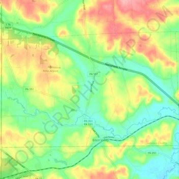
Name: Little Beaver Township topographic map, elevation, terrain.
Average elevation: 1,070 ft
Minimum elevation: 919 ft
Maximum elevation: 1,280 ft
Make a donation
Gear up for your next adventure:
As an Amazon Associate, this site earns from qualifying purchases at no extra cost to you.
Other topographic maps
Click on a map to view its topography, its elevation and its terrain.
West Pittsburg
United States > Pennsylvania > Lawrence County > Taylor Township
Average elevation: 915 ft
North Edinburg
United States > Pennsylvania > Lawrence County > Mahoning Township
Average elevation: 915 ft
West Pittsburg
United States > Pennsylvania > Lawrence County > Taylor Township
Average elevation: 915 ft
Make a donation
Gear up for your next adventure:
As an Amazon Associate, this site earns from qualifying purchases at no extra cost to you.
Lower East Side
United States > Pennsylvania > Lawrence County > New Castle > Lower East Side
Average elevation: 961 ft