Geolocate

Termini Imerese topographic map

Click on the map to display elevation.

About this map

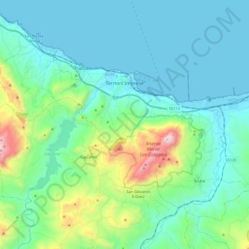
Name: Termini Imerese topographic map, elevation, terrain.

Location: Termini Imerese, Palermo, Sicily, 90018, Italy (37.90996 13.62139 37.99900 13.84384)

Average elevation: 804 ft

Minimum elevation: -3 ft

Maximum elevation: 4,288 ft

Other topographic maps

Click on a map to view its topography, its elevation and its terrain.

Sorgente di Montescuro

Italy > Sicily > Palermo > Prizzi

Average elevation: 2,726 ft

Bellacera

Italy > Sicily > Palermo > Santa Flavia

Average elevation: 531 ft

Finale

Italy > Sicily > Palermo

Average elevation: 276 ft

Santa Lucia

Italy > Sicily > Palermo > Cefalù

Average elevation: 167 ft

San Carlo

Italy > Sicily > Palermo > Chiusa Sclafani

Average elevation: 955 ft

Gear up for your next adventure:

🪶Paracord Bracelet - Survival bracelet with built‑in tools
📱Heavy-Duty Phone Cases - Drop-proof and waterproof protection for outdoor navigation
👟Trail Running Shoes - Lightweight shoes for trail runners
🌡️Portable Weather Meter - Track weather conditions on the trail
🥾Women's Hiking Boots - Top-rated trail boots with ankle support and superior grip

As an Amazon Associate, this site earns from qualifying purchases at no extra cost to you.