
Make a donation
Gear up for your next adventure:
As an Amazon Associate, this site earns from qualifying purchases at no extra cost to you.
Cártama topographic map
Click on the map to display elevation.
Make a donation
Gear up for your next adventure:
As an Amazon Associate, this site earns from qualifying purchases at no extra cost to you.
Cártama
The original town, Cártama Pueblo, stretches across the steep side of the Hill of the Virgin (240 m over the sea level). Its buildings and roads follow the contours of the hill, and reflect the varied topography of the area.
Make a donation
Gear up for your next adventure:
As an Amazon Associate, this site earns from qualifying purchases at no extra cost to you.
About this map
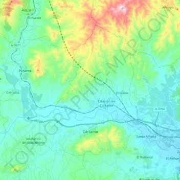
Name: Cártama topographic map, elevation, terrain.
Location: Cártama, Valle del Guadalhorce, Malaga, Andalusia, Spain (36.68762 -4.77897 36.80976 -4.56898)
Average elevation: 568 ft
Minimum elevation: 30 ft
Maximum elevation: 2,572 ft
Make a donation
Gear up for your next adventure:
As an Amazon Associate, this site earns from qualifying purchases at no extra cost to you.
Other topographic maps
Click on a map to view its topography, its elevation and its terrain.