
Make a donation
Gear up for your next adventure:
As an Amazon Associate, this site earns from qualifying purchases at no extra cost to you.
Kabati topographic map
Click on the map to display elevation.
Make a donation
Gear up for your next adventure:
As an Amazon Associate, this site earns from qualifying purchases at no extra cost to you.
About this map
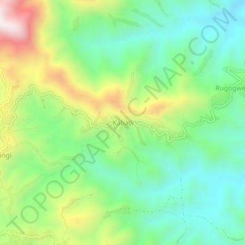
Name: Kabati topographic map, elevation, terrain.
Location: Kabati, North Kivu, Democratic Republic of the Congo (-1.20905 28.93144 -1.16905 28.97144)
Average elevation: 6,102 ft
Minimum elevation: 5,240 ft
Maximum elevation: 7,766 ft
Make a donation
Gear up for your next adventure:
As an Amazon Associate, this site earns from qualifying purchases at no extra cost to you.
Other topographic maps
Click on a map to view its topography, its elevation and its terrain.
Make a donation
Gear up for your next adventure:
As an Amazon Associate, this site earns from qualifying purchases at no extra cost to you.
Lava Lake of Mount Nyiragongo
Democratic Republic of the Congo > North Kivu > Nyiragongo
Average elevation: 10,118 ft
Make a donation
Gear up for your next adventure:
As an Amazon Associate, this site earns from qualifying purchases at no extra cost to you.