Geolocate

SoCal Sports Complex topographic map

Click on the map to display elevation.

About this map

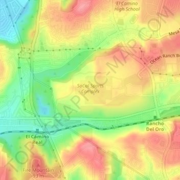
Name: SoCal Sports Complex topographic map, elevation, terrain.

Location: SoCal Sports Complex, Oceanside, San Diego County, CAL Fire Southern Region, California, United States (33.20388 -117.32570 33.20816 -117.31915)

Average elevation: 200 ft

Minimum elevation: 33 ft

Maximum elevation: 328 ft

San Diego County trails, hiking, mountain biking, running and outdoor activities

Other topographic maps

Click on a map to view its topography, its elevation and its terrain.

Oceanside

United States > California > San Diego County > Oceanside

Average elevation: 174 ft

Talich

United States > California > San Diego County > Oceanside

Average elevation: 210 ft

Gear up for your next adventure:

🏫Relief Map Kits - Hands-on tools for teaching landforms and elevation
🚪Portable Camp Chair - Foldable chair for comfort at camp
🥇GPS Hiking Watch - Multi‑sport GPS watch with navigation and trail tracking
🧭Pro Hiking Compasses - High-accuracy liquid-filled compasses for topographic orientation
🪶Survival Guide Book - Expert advice for emergency preparedness

As an Amazon Associate, this site earns from qualifying purchases at no extra cost to you.