
Make a donation
Gear up for your next adventure:
As an Amazon Associate, this site earns from qualifying purchases at no extra cost to you.
Pingbian topographic map
Click on the map to display elevation.
Make a donation
Gear up for your next adventure:
As an Amazon Associate, this site earns from qualifying purchases at no extra cost to you.
Pingbian
Pingbian County has a mild subtropical highland climate (Köppen Cwb) influenced by its elevation, with short, mild, dry winters and warm, humid summers. The monthly 24-hour average temperature ranges from 9.2 °C (48.6 °F) in January to 21.3 °C (70.3 °F) in July, and the annual mean is 16.3 °C (61.3 °F). The greatest rainfall tends to occur during the summer; spring is the sunniest season.
Make a donation
Gear up for your next adventure:
As an Amazon Associate, this site earns from qualifying purchases at no extra cost to you.
About this map
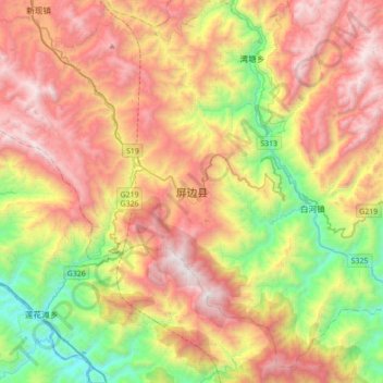
Name: Pingbian topographic map, elevation, terrain.
Average elevation: 3,829 ft
Minimum elevation: 348 ft
Maximum elevation: 7,618 ft
Make a donation
Gear up for your next adventure:
As an Amazon Associate, this site earns from qualifying purchases at no extra cost to you.