
Make a donation
Gear up for your next adventure:
As an Amazon Associate, this site earns from qualifying purchases at no extra cost to you.
Rumiñahui topographic map
Click on the map to display elevation.
Make a donation
Gear up for your next adventure:
As an Amazon Associate, this site earns from qualifying purchases at no extra cost to you.
About this map
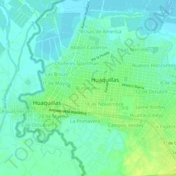
Name: Rumiñahui topographic map, elevation, terrain.
Location: Rumiñahui, Huaquillas, El Oro, 070503, Ecuador (-3.49664 -80.24936 -3.45664 -80.20936)
Average elevation: 23 ft
Minimum elevation: -7 ft
Maximum elevation: 56 ft
Make a donation
Gear up for your next adventure:
As an Amazon Associate, this site earns from qualifying purchases at no extra cost to you.
Other topographic maps
Click on a map to view its topography, its elevation and its terrain.
Huaquillas
Ecuador > El Oro > Huaquillas > Huaquillas
Huaquillas, es una ciudad ecuatoriana; cabecera del cantón homónimo, así como la cuarta urbe más grande y poblada de la Provincia de El Oro. Se localiza al extremo sur de la región litoral del Ecuador, muy cerca del océano Pacífico, en la frontera con Perú, en la orilla derecha del río Zarumilla, a…
Average elevation: 30 ft