
Make a donation
Gear up for your next adventure:
As an Amazon Associate, this site earns from qualifying purchases at no extra cost to you.
Saw Mill River topographic map
Click on the map to display elevation.
Make a donation
Gear up for your next adventure:
As an Amazon Associate, this site earns from qualifying purchases at no extra cost to you.
Saw Mill River
The Saw Mill River rises from a 1.75-acre (7,100 m2) pond in a wooded area of the town of New Castle roughly 2 miles (3.2 km) north of Chappaqua, a one-half mile (800 m) west of Quaker Road State Route 120 (NY 120) and just south of Stony Hollow Road, at an elevation of 490 feet (150 m) above sea level. It wends and meanders past a cemetery, between hills, through a residential area of houses on large wooded lots in a generally southward direction. Just north of Marcourt Drive, its first crossing, it is impounded to create another small pond. In this area it is frequently channelized and impounded as part of the landscaping on the area's large residential land lots. After crossing under Kipp Street, it bends eastward to cross under Quaker Road.
Make a donation
Gear up for your next adventure:
As an Amazon Associate, this site earns from qualifying purchases at no extra cost to you.
About this map
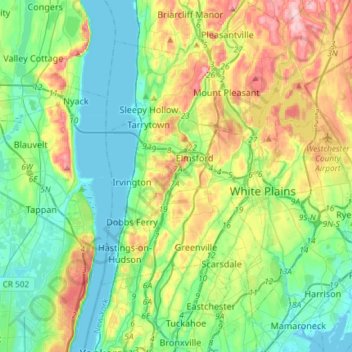
Name: Saw Mill River topographic map, elevation, terrain.
Average elevation: 226 ft
Minimum elevation: -7 ft
Maximum elevation: 745 ft
Make a donation
Gear up for your next adventure:
As an Amazon Associate, this site earns from qualifying purchases at no extra cost to you.