
Make a donation
Gear up for your next adventure:
As an Amazon Associate, this site earns from qualifying purchases at no extra cost to you.
Kangazha topographic map
Click on the map to display elevation.
Make a donation
Gear up for your next adventure:
As an Amazon Associate, this site earns from qualifying purchases at no extra cost to you.
About this map
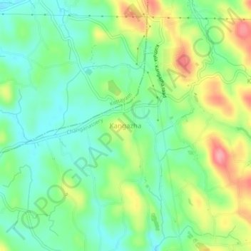
Name: Kangazha topographic map, elevation, terrain.
Location: Kangazha, Changanassery, Kottayam, Kerala, 686521, India (9.51394 76.65130 9.55394 76.69130)
Average elevation: 240 ft
Minimum elevation: 102 ft
Maximum elevation: 482 ft
Make a donation
Gear up for your next adventure:
As an Amazon Associate, this site earns from qualifying purchases at no extra cost to you.
Other topographic maps
Click on a map to view its topography, its elevation and its terrain.
Make a donation
Gear up for your next adventure:
As an Amazon Associate, this site earns from qualifying purchases at no extra cost to you.
Sri Subramanya swami Kshethra Kulam, Perunna
India > Kerala > Changanassery > Changanassery
Average elevation: 20 ft