Geolocate

Paburia topographic map

Click on the map to display elevation.

About this map

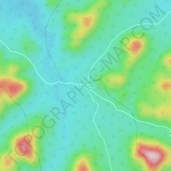
Name: Paburia topographic map, elevation, terrain.

Location: Paburia, Sarangagarh, Kandhamal, Odisha, 762112, India (20.14692 84.23531 20.18692 84.27531)

Average elevation: 2,297 ft

Minimum elevation: 2,024 ft

Maximum elevation: 3,094 ft

Gear up for your next adventure:

😴Insulated Sleeping Pads - Compact and warm pads for high-elevation camping
🪶Fire Starter Kit - Reliable fire starter for survival and camping
📖Nature Tracking Books - Learn to track wildlife and terrain
🧷Carabiner Set - Durable clips for gear attachment
🦺Reflective Outdoor Gear - Safety gear for low‑light conditions

As an Amazon Associate, this site earns from qualifying purchases at no extra cost to you.